


.jpg "Before the thunderstorm, Hai Duong continues to be hot and sunny")


.jpg "Reading culture in the digital age")


.jpg "What to see in Hai Duong newspaper on April 21?")


-a9f705f0fc2bb442b889e7ca8cfb4e9f.jpg "Prime Minister directs early payment of pensions in May")


.jpg "Parishioners joyfully celebrate Easter at Hai Duong Church")


Submit a comment
Storm KOINU is currently active in the sea northeast of Luzon Island (Philippines) and is forecast to gradually strengthen to level 14, gusting to level 17, and enter the East Sea in the next few days.
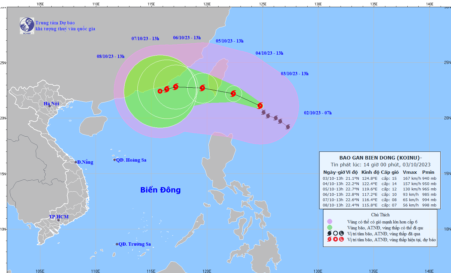
According to the National Center for Hydro-Meteorological Forecasting, at 1:00 p.m. on October 3, the center of the storm was located at about 21.1 degrees North latitude; 124.8 degrees East longitude, in the sea northeast of Luzon Island (Philippines). The strongest wind near the center of the storm was level 15 (167 - 183 km/h), gusting to level 17, moving northwest at about 10 km/h.
Forecast until about 13:00 on October 4, the storm will move in the West-Northwest direction, speed about 10km/h, storm intensity level 14, gust level 17, danger zone 19.0-24.0N; East of longitude 120.0E. Natural disaster risk level 3, affected area is Southeast of Taiwan (China).
At 1:00 p.m. on October 5, the storm moved in a West-Northwest direction at a speed of about 10km/h into the East Sea and gradually weakened to a strong storm intensity of level 12, gusting to level 15. The dangerous area is the area north of latitude 20.0N; east of longitude 117.0E, level 3 natural disaster risk, the affected area is in the Northeast of the North East Sea.
At 1:00 p.m. on October 6, the storm moved westward at a speed of about 10km/h and gradually weakened. The storm was located at 22.8N-117.2E, in the sea southeast of Guangdong province (China), with a storm intensity of level 10, gusting to level 12. The dangerous area is north of latitude 20.0N; east of longitude 115.5E, with a natural disaster risk level of level 3. The affected area is in the northeast of the North East Sea.
Experts predict that in the next 72 to 120 hours, the storm will move mainly in the West Southwest direction, about 5km per hour, and its intensity will continue to weaken.
Due to the impact of the storm, the northeastern sea area of the North East Sea from the night of October 3rd has winds gradually increasing to level 6-7, from the night of October 4th to level 8-10, near the storm center level 11-12, gusting to level 15; the sea is very rough.
The northeastern sea area of the North East Sea has waves 2 - 4m high; from the night of October 4, the waves are 4 - 6m high, near the storm center the waves are 6 - 8m high.
All vessels and other activities in the above sea areas are at high risk of being affected by strong winds and large waves.
On land, it is forecasted that on the night of October 3 and on October 4, in the Central Central region, there will be scattered showers and thunderstorms, locally with moderate rain, heavy rain with rainfall of 15-30mm, some places over 50mm. The South Central, Central Highlands and Southern regions will have scattered showers and thunderstorms, locally with heavy rain with rainfall of 20-40mm, some places over 70mm (rain concentrated in the afternoon and evening).
Thunderstorms may produce tornadoes, lightning and strong gusts of wind. Localized heavy rain may cause flooding in low-lying areas and the risk of flash floods and landslides in mountainous areas.