


.jpg "Before the thunderstorm, Hai Duong continues to be hot and sunny")


.jpg "Reading culture in the digital age")


.jpg "What to see in Hai Duong newspaper on April 21?")


-a9f705f0fc2bb442b889e7ca8cfb4e9f.jpg "Prime Minister directs early payment of pensions in May")


.jpg "Parishioners joyfully celebrate Easter at Hai Duong Church")


Submit a comment
According to the National Center for Hydro-Meteorological Forecasting, on the morning of July 23, storm No. 2 weakened into a tropical depression.
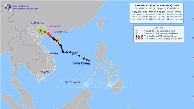
At 7:00 a.m., the center of the tropical depression was at about 21.3 degrees North latitude; 107.6 degrees East longitude, on the coastal area of Quang Ninh - Hai Phong. The strongest wind near the center of the tropical depression was level 7 (50-61 km/h), gusting to level 9, the tropical depression moved slowly in the West Northwest direction at a speed of 5-10 km/h.
Forecast until 7:00 p.m. on July 23, the tropical depression is in the Northeast region of the North and moving in the West Northwest direction at a speed of about 5-10 km/h and weakening into a low pressure area over the Northern mountainous region, wind below level 6, the area affected by the depression is the Northern Gulf of Tonkin. Natural disaster risk level 3.
Due to the influence of the tropical depression, on July 23, in the Gulf of Tonkin (including Bach Long Vi and Co To islands), there will be strong winds of level 6-7, gusting to level 9; rough seas.
The Gulf of Tonkin (including Bach Long Vi Island, Co To Island, and the coastal waters of Quang Ninh) has wave heights of 2-3m. On the afternoon of July 23, coastal areas from Quang Ninh to Nam Dinh need to be on guard against high tides, which will slow down the flood discharge on rivers and cause flooding in low-lying coastal and riverside areas.
On land, on the morning of July 23, the coastal area of Quang Ninh-Hai Phong had strong winds of level 6, gusting to level 8. The areas of Lang Son, Bac Giang, and Thai Binh had strong gusts of level 6.
From July 23 to 24, the Northern region and Thanh Hoa will have moderate rain, heavy rain and thunderstorms, and locally very heavy rain. Specifically, the Northeast and Thanh Hoa will have rainfall of 70-150mm, with some places having over 300mm; the Northwest and Nghe An will have rainfall of 50-100mm, with some places having over 200mm.
Due to the influence of storm No. 2, on Bach Long Vi island, there were strong winds of level 10, gusting to level 12; on Co To island, there were strong winds of level 6, gusting to level 10; in Tra Co, there were strong winds of level 9, gusting to level 10; in Cua Ong, there were strong winds of level 6, gusting to level 7; Dam Ha (Quang Ninh) had strong winds of level 6, gusting to level 9. The Northeast and Thanh Hoa had moderate rain, heavy rain, and some places had very heavy rain such as: Cat Ba (Hai Phong) 276mm, Cam Pha (Quang Ninh) 150mm...
In the face of the complicated developments of tropical depressions and floods, hydrometeorological experts recommend that people regularly monitor forecasts and warnings on the website of the National Center for Hydro-Meteorological Forecasting at nchmf.gov.vn, and provincial, municipal and regional hydrometeorological stations. At the same time, regularly update the latest hydro-meteorological forecasts on the official mass media of the Central and local governments to proactively respond.
The Department of Dyke Management and Natural Disaster Prevention and Control (Ministry of Agriculture and Rural Development) requests the Department of Agriculture and Rural Development of provinces and cities to report to the People's Committees of provinces and cities to direct relevant agencies and units to continue to strictly implement the Prime Minister's Official Dispatch No. 70/CD-TTg dated July 21, 2024 and the Official Dispatch of the Ministry of Agriculture and Rural Development, focusing on continuing to closely monitor the developments of low pressure, rain, floods, and inundation to direct and deploy timely response work, suitable to the specific situation in the locality, ensuring the safety of people's lives...
Provinces and cities need to arrange forces to guard, control, guide, and support traffic safety through culverts, landslide areas or areas at risk of landslides, deeply flooded areas, and areas with strong currents; resolutely not allow people and vehicles to pass if safety is not ensured; proactively arrange forces on duty at key and vulnerable areas to be ready to respond and rescue when situations arise...