


.jpg "Invite you to read Hai Duong newspaper special issue")
.jpeg "People rush to complete real estate procedures before 'G hour'")


.jpg "Outstanding domestic and international events on April 25")

.jpg "Agree on proposal to exempt and support tuition fees for students")
.jpg "Woman in Bac Ninh illegally bought and sold invoices worth more than 6,000 billion VND")
.jpg "US President Donald Trump announced that Chinese President Xi Jinping had contacted")

.jpg "Noi Bai Airport is expected to welcome 108,000 passengers on the peak day of April 30.")

.jpg "Hai Duong Power conducts disaster prevention and incident response drills in 2025")

Submit a comment
According to the forecast, at 1:00 a.m. on August 31, the center of the storm will be at 21 degrees North latitude - 119.4 degrees East longitude, moving northwest at a speed of about 10-15 km/hour, entering the East Sea, level 15, gusting above level 17.
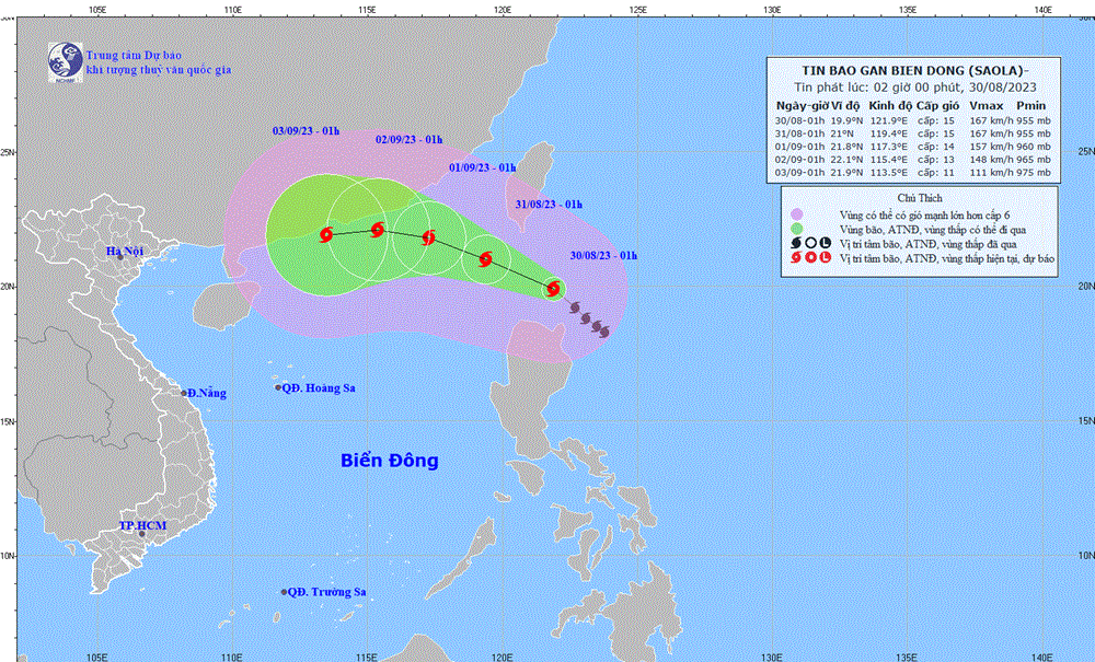
According to the National Center for Hydro-Meteorological Forecasting, at 1:00 a.m. on August 30, the center of storm Saola was located at about 19.9 degrees North latitude, 121.9 degrees East longitude, in the sea north of Luzon Island (Philippines). The strongest wind near the center of the storm was level 15 (167-183 km/h), gusting to level 17, moving northwest at a speed of 10-15 km/h.
At 1:00 a.m. on August 31, the center of the storm was at 21 degrees North latitude - 19.4 degrees East longitude, moving northwest at a speed of about 10-15 km/h, entering the East Sea, level 15, gusting over level 17. Dangerous areas affected by the storm: north of latitude 18 degrees North, east of longitude 118 degrees East; the east of the North East Sea area has a level 3 natural disaster risk.
At 1:00 a.m. on September 1, the center of the storm was at 21.8 degrees North latitude - 117.3 degrees East longitude, moving West Northwest at a speed of about 10km/hour, entering the East Sea, level 14, gusting to level 17.
Dangerous areas affected by storms: North of latitude 18 degrees North, East of longitude 115 degrees East; Northeast of the North East Sea area has level 3 natural disaster risk.
At 1:00 a.m. on September 2, the center of the storm was at 22.1 degrees North latitude - 115.4 degrees East longitude, moving West Northwest at a speed of about 10km/h, level 13, gusting over level 16. Dangerous areas affected by the storm: North of latitude 18 degrees North, East of longitude 112.5 degrees East; the North of the North East Sea area has a level 3 natural disaster risk.
From the next 72 to 120 hours, the storm will move mainly in a westerly direction, about 10km per hour, and its intensity will likely weaken.
Due to the influence of the storm, the northeastern sea area of the North East Sea has strong winds of level 6, from the afternoon and night of August 30, it will increase to level 7-8, near the storm center it will be level 10-12, then increase to level 13-15, gusting above level 17; the sea will be very rough.
During the day and night of August 30, the area from Quang Binh to Quang Ngai, the Central Highlands and the South will have scattered showers and thunderstorms, locally heavy to very heavy rain with rainfall of 20-40mm, some places over 80mm (rain concentrated in the evening and at night).
Thunderstorms and localized heavy rain in the Central Central region are likely to last until around August 31. The Central Highlands and Southern regions are likely to continue in the coming days.
Localized heavy rains are likely to cause flooding in low-lying areas and the risk of flash floods and landslides in mountainous areas. Warning level of natural disaster risk due to tornadoes and lightning: level 1.
Weather in the regions during the day and night of August 30, the Northwest region is sunny during the day, with some rain at night. Light wind. Lowest temperature 22-25 degrees Celsius, some places below 22 degrees Celsius. Highest temperature 31-34 degrees Celsius, some places above 34 degrees Celsius.
In the Northeast, it is sunny during the day and raining in some places at night. Northeast to North wind level 2-3. Lowest temperature 24-27 degrees Celsius. Highest temperature 31-34 degrees Celsius.
Hanoi capital is sunny during the day and rainless at night. Northeast to North wind level 2-3. Lowest temperature 25-27 degrees Celsius. Highest temperature 32-34 degrees Celsius.
The provinces from Thanh Hoa to Thua Thien-Hue in the North will be cloudy, sunny during the day, with rain in some places at night; in the South, it will be cloudy, with showers and thunderstorms in some places during the day, with showers and scattered thunderstorms in the evening and at night, with heavy to very heavy rain in some places; in thunderstorms, there is a possibility of tornadoes, lightning and strong gusts of wind. North to Northwest wind level 2-3. Lowest temperature 23-26 degrees Celsius. Highest temperature 30-33 degrees Celsius, with some places above 33 degrees Celsius.
Provinces and cities from Da Nang to Binh Thuan have scattered showers and thunderstorms during the day, especially in the South, sunny during the day, some places are hot; in the evening and at night there are scattered showers and thunderstorms, locally heavy to very heavy rain; in thunderstorms there is a possibility of tornadoes, lightning and strong gusts of wind. Southwest wind level 2-3. Lowest temperature 23-26 degrees Celsius. Highest temperature 31-34 degrees Celsius, some places above 34 degrees Celsius.
The Central Highlands region has scattered showers and thunderstorms, with scattered showers and thunderstorms in the afternoon and evening, with localized heavy to very heavy rain; thunderstorms are likely to cause tornadoes, lightning, and strong gusts of wind. Southwesterly winds level 2-3. Lowest temperature 19-22 degrees Celsius. Highest temperature 27-30 degrees Celsius.
The South has scattered showers and thunderstorms, with scattered showers and thunderstorms in the afternoon and evening, with localized heavy to very heavy rain; thunderstorms are likely to produce tornadoes, lightning, and strong gusts of wind. Southwesterly winds level 2-3. Lowest temperature 24-27 degrees Celsius. Highest temperature 31-34 degrees Celsius.
According to Vietnam+
.jpg "The violator has removed the surrounding wall and iron net around the Bac Hung Hai bridge pillar.")