


.jpg "Seized a large amount of processed food without invoices or documents in Hai Duong City")

.jpg "Hai Duong handles 217 traffic violations in the first half day of the holiday")


.png "Podcast News April 30")


.jpg "Mother Buoi has husband and son who sacrificed for the Fatherland")

Submit a comment
As part of the 2023 traffic planning roadmap, Hanoi is preparing to build three bridges over the Red River: Tran Hung Dao, Tu Lien and Van Phuc.
The Hanoi Traffic Construction Investment Project Management Board said that the Van Phuc Bridge construction investment project across the Red River and the connecting road to National Highway 32, Phuc Tho district, is striving to approve the project's pre-feasibility study report in 2023.
The investment project to build Tu Lien bridge and the road from Tu Lien bridge to Hanoi - Thai Nguyen expressway is implementing the project feasibility study report, expected to be submitted in the third quarter.
Regarding Tran Hung Dao Bridge, the committee has completed the work of organizing the display, exhibition and consulting the community on the bridge's architectural plan and the City People's Committee has approved the results of the architectural plan competition.
The city has approved the assignment of an enterprise to prepare a dossier proposing an investment policy and a pre-feasibility study report for the project under the PPP method and BOT contract type for appraisal.

The architectural plan of the bridge is a cable-stayed bridge, combining torsion beams, creating large spans with a light steel frame system, two main bridge piers are shaped. Source: Hanoi Department of Planning and Architecture
Tu Lien BridgeAccording to the decision approving the results of the selection of architectural design options, the bridge construction site will be located between Nhat Tan Bridge and Long Bien Bridge, connecting Tay Ho District with Dong Anh District; connecting from the planned urban main road along Huu Hong Dike with National Highway 5 extension, in Tay Ho District, Long Bien District and Dong Anh District.
The planned scope has the starting point at the intersection with Nghi Tam Street, the end point at the intersection of National Highway 5, the total straight length is about 4.8 km. With 5 intersections in the section including: Nghi Tam intersection; Huu Hong intersection; Intersection connecting the middle beach; Ta Hong intersection; Intersection of National Highway 5 extension.
The bridge's architectural plan is a cable-stayed bridge, combining torsion beams, creating large spans with a light steel frame system, and two main bridge piers are shaped.
Tran Hung Dao Bridge, along with Tu Lien bridge, this project is located in the central urban area and has been selected for architectural design. Tran Hung Dao bridge is located between Chuong Duong and Vinh Tuy bridges. The south side of the bridge connects to Tran Hung Dao street at the border of Hoan Kiem and Hai Ba Trung districts. In the north, the bridge crosses the Red River bank, follows the western edge of Gia Lam airport area, to the planned intersection with Nguyen Van Linh street (National Highway 5A). The starting point is at the intersection of Tran Hung Dao - Tran Thanh Tong - Le Thanh Tong, the end point is at the intersection with Vu Duc Thuan street.

The architectural plan of Tran Hung Dao bridge was chosen by Hanoi City. Source: Provided by the Organizing Committee
The main bridge is 900 m long, including 6 spans, the total length of the bridge and the approach roads at both ends is about 5.5 km, passing through Hoan Kiem, Hai Ba Trung, Long Bien districts. The bridge has two directions, each direction has two lanes for motor vehicles and one lane for mixed vehicles. In addition, the open spaces are used to arrange bicycle lanes close to the arch. The pedestrian path is outside the arch. The bridge head has an up and down ramp for pedestrians. The bridge piers have observation towers to serve the sightseeing needs of the people and create structural highlights. There are parks at both ends of the bridge for people to enjoy and entertain.
Van Phuc Bridgeand the connecting route to National Highway 32, Phuc Tho district, 7.7 km long. The starting point is at the intersection of National Highway 32, in Phung Thuong commune, Phuc Tho district; the end point is at the border of Hanoi and Vinh Phuc province.
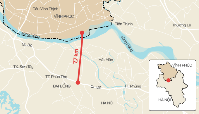
Construction location of Van Phuc bridge and connecting route to National Highway 32. Graphics: Tien Thanh
The main bridge over the river, the viaduct over Van Coc lake and the approach bridge towards Hanoi are 20.5 m wide, with 4 lanes for motor vehicles and 2 lanes for non-motor vehicles. The road connecting from National Highway 32 to the viaduct over Van Coc lake is 32 m wide, with 6 lanes for motor vehicles and 2 lanes for non-motor vehicles.
According to the Hanoi People's Committee, the construction of Van Phuc Bridge aims to complete the planned traffic system, serve the needs of goods circulation and travel of the people, create a premise to promote socio-economic development in Hanoi, Vinh Phuc and neighboring provinces and cities in the capital region and the Northern key economic region.
Tu Lien, Tran Hung Dao, Van Phuc are 3 of 10 bridges across the Red River built according to the transport planning until 2030, vision to 2050. The remaining 7 bridges include Hong Ha, Me So (ring road 4), Thang Long Moi (ring road 3), Vinh Tuy (phase 2), Thuong Cat, Ngoc Hoi (ring road 3.5), Phu Xuyen bridge. Currently, Hanoi has 8 bridges across the Red River: Thang Long, Chuong Duong, Vinh Tuy (phase 1), Thanh Tri, Nhat Tan, Vinh Thinh, Long Bien, Viet Tri - Ba Vi.
According to VnExpress


