


Submit a comment
A tropical depression in the central Philippines has strengthened into typhoon Ewiniar, which is not expected to move into the South China Sea.
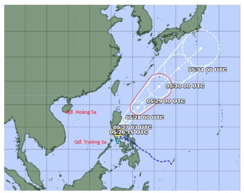
At noon on May 26, information from the General Department of Hydrometeorology said that on the morning of the same day, the tropical depression in the central region of the Philippines had strengthened into a storm, typhoon Ewiniar.
This is the first storm to appear in the Northwest Pacific region this year's storm season.
The first storm to appear in the Northwest Pacific in late May is called late and its appearance time is about 1 month later than the average of many years.
It is forecasted that in the next 24 hours, storm Ewiniar will move north, then change direction to north-northeast and move back to the Northwest Pacific Ocean on the morning of May 28.
"With this direction of movement, storm Ewiniar is forecasted not to move into the East Sea. The National Center for Hydro-Meteorological Forecasting is still closely monitoring the developments of this storm," the General Department of Hydro-Meteorology stated.
According to the forecast of the National Center for Hydro-Meteorological Forecasting, on the day and night of May 26, the eastern sea area of the central East Sea and the southern East Sea (including the waters of the Truong Sa archipelago) will have showers and thunderstorms.
During thunderstorms, there is a possibility of tornadoes and strong gusts of wind level 6-7. Beware of wave heights that may increase to over 2m.
All vessels operating in the above areas are at high risk of being affected by tornadoes, strong winds and large waves.
On the mainland of our country, on May 26, the mountainous areas from Nghe An to Phu Yen will be hot, with some places experiencing severe heat. From May 27, the heat will expand to the area from Thanh Hoa to Phu Yen with the highest temperature of 35-37 degrees Celsius, some places above 37 degrees Celsius, and the lowest relative humidity of 50-55%.
The South continues to be hot with the highest temperature commonly ranging from 35-36 degrees Celsius, with some places above 36 degrees Celsius. From May 27, the heat in this area tends to decrease gradually.
The meteorological agency noted that the predicted temperature in the heat bulletin and the actual felt temperature outside can differ by 2-4 degrees Celsius, or even higher depending on the conditions of the surface such as concrete and asphalt.
TH (according to VTC News)