


.jpg "11 big problems in science, technology, innovation and digital transformation of Hai Duong")


.jpeg "Difficult things should not be done carelessly.")


.jpg "Hai Duong traffic focus on May 10")


Submit a comment
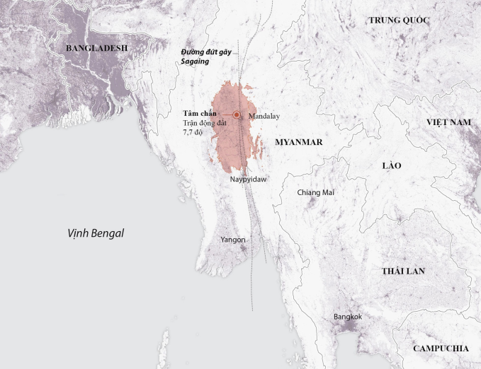
In the worst-case scenario, the 7.7-magnitude earthquake that just struck Myanmar could kill 100,000 people and cause economic damage of $10-100 billion.

The US Geological Survey (USGS) on March 28 announced a preliminary assessment of the 7.7 magnitude earthquake in central Myanmar, estimating a 35% chance of 10,000-100,000 deaths and a 36% chance of 100,000 or more.
The prediction was made based on the epicenter's location about 16 km northwest of Myanmar's Sagaing City and the quality of surrounding infrastructure.
"Residents in this area generally live in structures that are vulnerable to earthquakes, although there are some solid buildings. Vulnerable structures are those built according to non-standard construction and are made of unsound bricks," the report said.
The USGS also estimated that there was a 35% chance that the earthquake would cause economic damage of between $10 billion and $100 billion, equivalent to about one-third of Myanmar's GDP.
The country’s worst-hit cities included Mandalay, Kyaukse and Taungoo, which all recorded strong tremors. Past data shows that earthquakes of similar magnitude in the region have killed thousands of people and created secondary hazards such as landslides.
According to the USGS, the scale of the disaster shows that the international community needs to immediately provide emergency aid and conduct rescue and relief operations to minimize the economic and humanitarian impact.
Myanmar officials have not commented on the information. General Min Aung Hlaing, the leader of the Myanmar government, said on the evening of March 28 that the earthquake had killed 144 people and injured more than 730, adding that the death toll would continue to rise.
He stressed that Myanmar is ready to receive support and donations from all countries and organizations in the world, adding that routes have been opened for international aid to reach the country.
In Thailand, at least 10 people have died in the capital Bangkok due to the impact of an earthquake from Myanmar and more than 100 people are still trapped in the collapse of a high-rise building under construction in the city.
Earthquakes are quite frequent in Myanmar, where six earthquakes of magnitude 7 or greater were recorded between 1930 and 1956, near the Sagaing fault line that runs from north to south.
Experts say the breakneck pace of development in Myanmar's cities, combined with crumbling infrastructure and poor urban planning, has also left the country's most populous areas vulnerable to earthquakes and other disasters.
TB (summary)


.jpg "Hai Duong completed the target of each locality building 15 new houses for policy families, poor and near-poor households.")